

Story Highlights
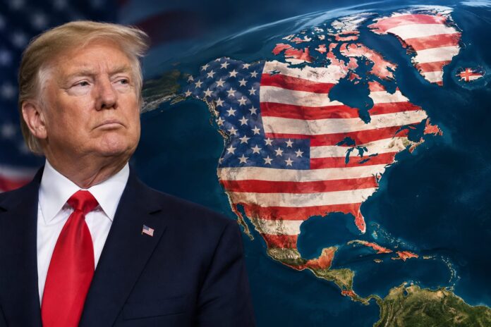
- President Trump posts a provocative map featuring the American flag over North America.
- The display aligns with his past ambitions to expand U.S. influence beyond its borders.
- Critics view the map as controversial, but it reflects a strong commitment to American presence.
- The post comes amid ongoing trade tensions with Canada.
What Happened
President Trump made headlines on Monday morning when he shared a striking map on his social media platform, Truth Social. The map prominently displayed the American flag superimposed over a vast expanse of North America, including Canada, Mexico, and parts of Central America, as well as Greenland and Iceland. This bold visual representation has sparked a wave of reactions, with many interpreting it as a continuation of his administration’s territorial ambitions. The president’s post follows a series of previous assertions regarding U.S. interests in territories beyond its borders, including Greenland and the Panama Canal. The inclusion of Mexico and Caribbean islands like Cuba and Jamaica in this latest display marks a new chapter in his vision for American expansion.
The map was posted on Truth Social on Monday morning, and it features the American flag over Canada, Mexico, and parts of Central America. Trump has previously expressed interest in acquiring Greenland and the Panama Canal. The post coincides with rising trade tensions between the U.S. and Canada, where tariffs have recently been imposed by both nations. This provocative display has reignited discussions about U.S. territorial ambitions and the implications of such claims on international relations.
- The map was posted on Truth Social on Monday morning.
- It features the American flag over Canada, Mexico, and parts of Central America.
- Trump has previously expressed interest in acquiring Greenland and the Panama Canal.
- The post coincides with rising trade tensions between the U.S. and Canada.
Why It Matters
The implications of President Trump’s map are significant, particularly in the context of U.S. foreign policy and trade relations. By showcasing a map that suggests a bold territorial claim, the president is reinforcing his administration’s stance on American exceptionalism and influence in the Western Hemisphere. This display can be interpreted as a strategic move to assert dominance amid ongoing trade disputes with Canada, where tariffs have recently been imposed by both nations. Critics may argue that such a display is provocative and could exacerbate tensions, but supporters view it as a necessary assertion of American strength and leadership. The map serves as a reminder of Trump’s unwavering commitment to prioritizing American interests, even in the face of international criticism. The reactions to this map highlight the polarized views on U.S. foreign policy under Trump’s administration.
- The map reinforces Trump’s vision of American exceptionalism.
- It coincides with recent trade disputes between the U.S. and Canada.
- Critics argue it could escalate tensions, while supporters see it as a show of strength.
- The display reflects a broader strategy of asserting U.S. influence in the region.
Political and Public Context
To fully understand the significance of this map, it is essential to consider the broader context of U.S. foreign policy under President Trump. His administration has consistently sought to redefine America’s role on the global stage, often prioritizing national interests over traditional diplomatic norms. The president’s previous attempts to acquire Greenland and his recent executive order to rename Lake Ontario to ‘Lake America’ illustrate a pattern of asserting U.S. claims in a manner that challenges conventional diplomatic practices. Furthermore, the ongoing trade tensions with Canada, which have seen both nations imposing tariffs on each other’s goods, highlight the complexities of U.S.-Canada relations. This map serves as a visual representation of the president’s approach to foreign policy, one that is characterized by boldness and a willingness to challenge the status quo. The public’s reaction to this map also reflects the divided opinions on Trump’s foreign policy strategies.
- Trump’s administration has sought to redefine America’s global role.
- Previous attempts to acquire Greenland reflect a pattern of assertive diplomacy.
- Trade tensions with Canada complicate U.S.-Canada relations.
- The map symbolizes a challenge to traditional diplomatic norms.
Mediaite: President Trump raised eyebrows and sparked criticism on both sides of the aisle on Monday by posting a map of the United States expanding to include both Canada and Mexico.
Many pundits and observers on the left questioned Trump’s mental well-being and accused him of… pic.twitter.com/5c1UCP3KhR
— Politics & Poll Tracker 📡 (@PollTracker2024) September 7, 2026
What Happens Next
Looking ahead, the fallout from President Trump’s map is likely to unfold in several ways. First, it may prompt further discussions about U.S. territorial ambitions and the implications of such claims on international relations. Critics may escalate their opposition, potentially leading to diplomatic repercussions. On the other hand, supporters of the president may rally around this display as a testament to his commitment to American interests. Additionally, the ongoing trade tensions with Canada will likely continue to be a focal point, with both nations needing to navigate their relationship carefully to avoid further escalation. The map raises open questions about the future of U.S. foreign policy and how it will be shaped by the current administration’s bold assertions. As the situation develops, the international community will be watching closely to see how these dynamics play out.
- Discussions about U.S. territorial ambitions may intensify.
- Critics could escalate their opposition, leading to diplomatic repercussions.
- Supporters may rally around the president’s display as a show of strength.
- Ongoing trade tensions with Canada will remain a critical issue.